Community mapping in Misungwi, Tanzania using qualitative methods (and drones!)
Claudia Duguay (PhD cand.), February 2023

I travelled to Tanzania for the second time in August of 2021 to conduct essential field work for one of my doctoral research projects. This project complements a recent cross-sectional study completed in February 2022 in Misungwi, Tanzania that aimed to understand risk factors that are associated with malaria and schistosomiasis infection (see blog post 1). The goal of this study was to identify potential malaria mosquito larval breeding sites and freshwater snail habitats (responsible for schistosomiasis) in Misungwi, Tanzania using a community mapping approach. This project can be broken down into three stages: 1) community mapping, 2) community walkthrough, and 3) drone imagery.

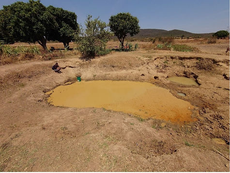
The walkthrough proved to be a very valuable activity to contextualize the findings of the cross-sectional that offered evidence that nearly 100% of children in the three villages had been exposed to schistosomiasis. When I first saw the results of the cross-sectional study, I immediately thought that the rapid tests that we were using were faulty. However, after doing our walkthrough and understanding water use and behaviour – the results are plausible. In the three villages that we visited, not a single household or person had access to clean water. There were water pumps in most villages, but residents noted that nobody used them because the water tasted salty.
We found that households depend on natural springs and dug wells for drinking water and all domestic use (bathing and cleaning). I did not have the opportunity to test the water, but by visual inspection, the potential for water-borne diseases was very clear.
The third stage of the project was to collect drone-imagery data of the three villages to identify potential mosquito larval breeding sites and snail habitats (essentially any type of water body in the three villages). We worked with Notice Kilimanjaro, an experienced and authorized Tanzanian drone operating media company (TCAA authorized and licensed) to carry out drone flights across the selected sites. This information will allow us to accurately assess individual- and household-level exposures to malaria and schistosomiasis in Misungwi, Tanzania.
Although this project was exploratory in nature, it helped me contextualize and understand the cross-sectional data that forms one of my doctoral research projects.

The first stage of this project involved working with 10 community members (5 female and 5 males) to draw a map of their village. They were given different coloured markers to identify features that they thought were important. I then probed them to identify the different bodies of water in their village, their specific use, seasonality, and if it was a human-only or mixed (for humans and cattle) water source. This stage of the project allowed me to get a sense of the number and location of the bodies of water being used in the three selected villages. This stage directly fed into the second stage which was to visit all the bodies of water identified by the community (the walkthrough) to identify potential mosquito larval breeding sites and snail habitats. We quickly realized that there were many more bodies of water than what was identified in the maps.


